In May and June, inspired by Julie Peakman's book, Hitler's Island War, and informed by Anthony Rogers' earlier book, Churchill's Folly, we explored the battlefields of Leros. I have not put all the pictures in the blog because they will probably not interest those who do not know anything of the battle, which was Britain's last major defeat of the Second World War, in which thousands of men lost their lives, were wounded or were taken prisoner as a result of Churchill's intransigence and the incompetence of their commander. Anybody who knows Leros should read Julie's excellent book. Those too tight to buy it or too lazy to read it can always turn to Wikipedia. I won't tell the story of the battle here, but just put up our photos of the main locations of the battle featured in the books. One place we could not find was the tunnel under Meroviglia which was Brigadier Tilney's command headquarters and from which he surrendered the island, to the shock of the troops who had fought so hard and were ready to fight on.
The British did not have much faith in the Italians, many of whom were reluctant to fight against their former allies, but some of whom displayed great heroism in the battle. Tilney's defensive strategy was to spread his troops all over the island. The German's strategy was to take the centre of the island, to split the north from the south, and to secure Alinda Bay, so that they could land heavy weapons and supplies. That, however, was a major task, because Alinda Bay was surrounded by mountains, most of which had heavy guns in place, from Clidi and the surrounding heights in the north, through Meraviglia in the centre, to Apetici in the south east.The Germans had command of the air and bombed remorselessly throughout the battle. They first landed troops on the east side of the island, to attack Apetici and towards Clidi, then landed paratroops in Gourna and Alinda, on either side of the Rachi ridge. Below are two maps from Anthony Rogers book, showing the Italian batteries, the disposition of the British troops and the German landing places.


Apetiki
 |
| Apetiki from the north, The Germans landed on the left and had to advance up this hill, through the scrub, under fire from the top. |
On May 27th we cycled up to Christos, above Platanos, and walked up to Apetiki, the hill east of the castle, with Italian gun emplacements on the top, which was attacked by the Germans, who landed on the rocks below on 12, 13 and 14 November 1943. This was one of the hardest fought-over points of the battle, changing hands several times over the five days of the battle.
 |
| This is where the Germans landed to assault Apetiki |
 |
| Gun emplacement at the top of Apetiki |
 |
| Look-out and machine-gun post at the top of Apetiki |
 |
| View west from the top of Apetiki. Castle and then Alinda Bay to the right |
 |
| View south west from Apetiki |
 |
| Pandeli and Lakki Bay from Apetiki |
 |
| Bolts on gun emplacement on Apetiki |
 |
| Gun emplacement on Apetiki |
 |
| One of many tunnels on Apetiki |
 |
| The castle and Platanos from Apetiki |
One thing we did not find on Apetiki was pictures engraved on the rocks, because Al and Kitty only told us where they are when we came back - they are on the left of the track just before the barrier before the more modern Greek barracks.
Meroviglia
On May 29th we went up to Meroviglia, which was the central stronghold and command point of the island defences. We cycled up to The Anchor, which was and is now the road junction between the road between Lakki and Platanos and the road to Gourna, then walked up a track to the top of Meroviglia. The remains of the Italian batteries are intermingled with more recent Greek military building.
 |
| The anchor - the junction between the road to Platanos and the road to Rachi and Gourna (and to the excellent private war museum) |
 |
| "Charing Cross" on the road below Meroviglia |
 |
| Cave entrance on way up to Meroviglia |
 |
| Inside the cave on the way up to Meroviglia - we didn't have a torch! |
 |
| Apetiki from Meroviglia |
 |
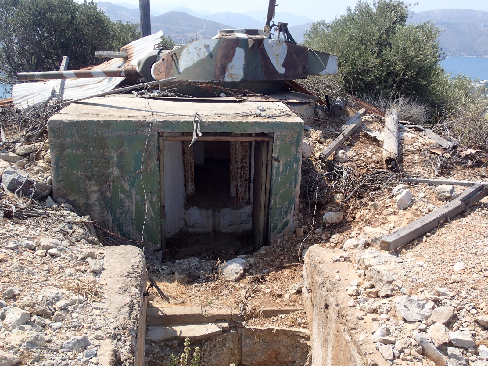
| Tunnel with closed door at eastern end of Meroviglia |
 |
| Blockhouse at eastern end of Meroviglia |
 |
| Tunnel entrance at eastern end of Meroviglia |
 |
| The castle from Meroviglia |
 |
| Tunnel entrance at eastern end of summit of Meroviglia |
 |
| Ammunition store on Meroviglia - each gun is attached to an ammunition store |
 |
| Entrance to ammunition store - No Smoking |
 |
| Cross on top of former gun emplacement on the summit of Meroviglia |
 |
| Gun emplacement from the ammunition store |
 |
| Gun emplacement at western summit of Meroviglia |
 |
| Rachi ridge from Meroviglia - The searchlight in foreground |
 |
| Gourna from Meroviglia |
Meroviglia has a commanding view all round Leros, as these panoramic pictures show
 |
| Lakki Bay from Meroviglia |
 |
| Gourna Bay from Meroviglia -"the windmill" at left |
 |
| Rachi ridge from Meroviglia, Gourna left and Alinda right. |
 |
| Alinda Bay from Meroviglia |
 |
| Agia Marina and Platanos from Meroviglia |
 |
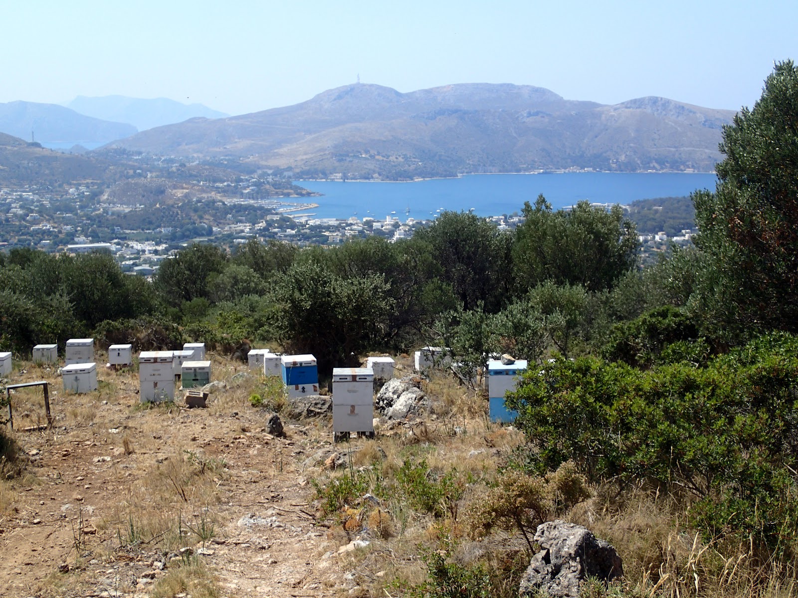
| Beehives and Lakki Bay from the track up to Meroviglia |
 |
| Meroviglia gun emplacement |
 |
| Platanos, the castle and Apetiki from gun emplacement |
 |
| Meroviglia Tunnel to gun emplacement |
 |
| Meroviglia Tunnel near church |
 |
| Lakki Bay from Meroviglia |
 |
| Windmill Hill |
 |
| Searchlight Hill |
Clidi
On June 11th we motored down the east coast of Leros to explore the German landing points for the assault on Clidi and the surrounding peaks. As at Apetiki, the infantry had to land on rocky shores or small beaches and struggle up steep, rocky, scrub-covered slopes under fire from above.
 |
| Clidi range from the South - Vagia on the left, Clidi the highest peak, Vedetta to the right. |
In addition to Apetiki, the first wave of the invasion landed on 12th November at Vagia Bay and on the north side of Point Sopra
 |
| Vagia Bay |
 |
| Landing point north of point Sopra |
Another landing craft was damaged by shellfire and drifted onto the islet of Strongili, used now as then for target practice. The allied gunners had just been practicing firing at Strongili so had no trouble in destroying the stricken landing craft.
 |
| Strongili, with target for gunners marked out |
The initial target of the first wave was Mount Vedetta, 64 metres above them.
 |
| Vedetta from a point between Vagia and Sopra |
The second wave landed on 13 November at Apetiki, on the north and south sides of Sopra, in Grifo Bay and at Panagies Beach, further into Alinda Bay no picture, but you can Google it.
 |
| Landing point on south side of Sopra |
 |
| Grifo Bay |
So now you can go and read Julie's book to give human content to the pictures
https://www.amazon.co.uk/Hitlers-Island-War-Fought-Leros/dp/1784532681